
Forum
»
Tracking Hurricane Florence....Misc Weather crew Assemble!
 09-10-2018, 09:55 AM
-
#91
- dabbmw2002
- Trolling the trolls.....
-

- dabbmw2002
- Trolling the trolls.....
- Join Date: Jan 2007
- Location: Maryland, United States
- Posts: 73,334
- Rep Power: 713784
-
-

Post deleted by user
Original Ruckus
09-10-2018, 09:57 AM
-
#92
- darkninja67
- The Dark Lord
-

- darkninja67
- The Dark Lord
- Join Date: Aug 2009
- Posts: 87,403
- Rep Power: 802217
-
-
Just downgraded by NOAA to sunshowers.
Stay safe NC guys
Stay safe NC guys
rumpler of stiltskins
"I'm not afraid to die, I'm afraid I'll survive and have to watch you suffer" - Thy Art Is Murder
"Life will cease so breathe deep" - Lorna Shore
09-10-2018, 10:00 AM
-
#93

- Muzzlrpress
- Join Date: Jan 2011
- Location: United States
- Posts: 104,332
- Rep Power: 993953
-
-
If it isn't at least a 4, it's a waste of time and space.
I'm back, bitches!
09-10-2018, 10:11 AM
-
#94

 09-10-2018, 10:11 AM
-
#95
- dawktwenty
- 007
-

- dawktwenty
- 007
- Join Date: Oct 2007
- Location: United States
- Age: 41
- Posts: 7,783
- Rep Power: 48875
-
-
This will reach cat 4/cat 5. Not saying it'll make landfall as that. But she'll rapidly intensify over the next 12-36 hours.
PHILLIES/EAGLES CREW
{} MFC {}

 09-10-2018, 10:20 AM
-
#97
- tunafish01
- Registered User
-

- tunafish01
- Registered User
- Join Date: Jul 2017
- Age: 56
- Posts: 2,393
- Rep Power: 5787
-
-
Originally Posted By dawktwenty⏩
tempted to neg,This will reach cat 4/cat 5. Not saying it'll make landfall as that. Butshe'llrapidly intensify over the next 12-36 hours.
dont assume the hurricanes gender
09-10-2018, 10:20 AM
-
#98
 09-10-2018, 10:22 AM
-
#99
 09-10-2018, 10:28 AM
-
#100

- BigTimeOperator
- Join Date: Jul 2017
- Posts: 13,375
- Subscribers: 1
- Rep Power: 113864
-
-
^ LOL! that guy is awesome!
09-10-2018, 10:32 AM
-
#101
09-10-2018, 10:37 AM
-
#102

Cat 4 now oh lawd
PC specs
i9 9900k/AMD RX 6800 16 GB/16 GB RAM/LG BX 65'' OLED/Gigabyte GS27QC 27''
OLED Master Race crew
1440p 120+ fps only crew
6'2 master race crew
Audiophile crew
Metal crew
Introvert/INTJ crew
German crew
If you aren't getting stronger you aren't getting bigger crew
09-10-2018, 10:38 AM
-
#103
 09-10-2018, 10:39 AM
-
#104
- AquilaConfido
- Banned
-

- AquilaConfido
- Banned
- Join Date: Oct 2013
- Location: London, United Kingdom (Great Britain)
- Age: 42
- Posts: 6,222
- Rep Power: 0
-
-
Sleep tight NC puppers.
Joking, stay safe puppers, srs.
Joking, stay safe puppers, srs.
09-10-2018, 10:45 AM
-
#105
Originally Posted By dawktwenty⏩
Not exactly a bold prediction... they've said it'll be a cat 4 since it was just a TS. Cat 5 is predicted by a few models, but not the majority. Probably sitting at around 20% or so chance I'd guess. It made cat 4 pretty damn quick though, even based on predicitons. Could indicate a higher chance at 5.This will reach cat 4/cat 5. Not saying it'll make landfall as that. But she'll rapidly intensify over the next 12-36 hours.
I'm on the ocean up in VA Beach. Not going to lie, am nervous if it takes a turn north which people have said could happen if it rapidly intensifies.
*Certified ****head Crew*
*US Navy Crew*
09-10-2018, 10:58 AM
-
#106
- soaponarope1
- 6'2" 227
-

- soaponarope1
- 6'2" 227
- Join Date: Jun 2016
- Location: Florida, United States
- Age: 40
- Posts: 13,552
- Rep Power: 63078
-
-
Remember to stock up on beer, meat for the grill, water and some ice for the cooler boyos.
09-10-2018, 11:05 AM
-
#107
09-10-2018, 11:10 AM
-
#108
- armyr0b
- Registered User
-

- armyr0b
- Registered User
- Join Date: Jan 2008
- Location: Connecticut, United States
- Age: 46
- Posts: 6,321
- Rep Power: 21214
-
-
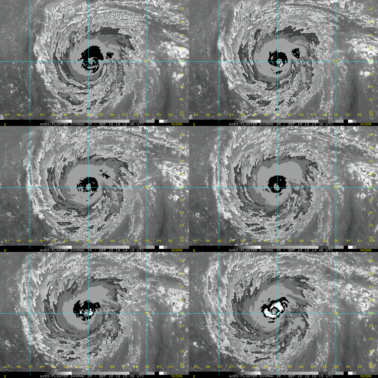
per the National Hurricane Center: FYI cat 5 storms start at 157MPH sustained winds and she isnt even in hot water.
Hurricane Florence Tropical Cyclone Update
NWS National Hurricane Center Miami FL AL062018
1200 PM AST Mon Sep 10 2018
...FLORENCE BECOMES A CATEGORY FOUR HURRICANE...
Data from a NOAA Hurricane Hunter aircraft indicate that Florence
has continued to rapidly stregthen and has maximum sustained winds
near 130 mph (195 km/h). The latest minimum central pressure based
on data from the aircraft is 946 mb (27.93 inches).
SUMMARY OF 1200 PM AST...1600 UTC...INFORMATION
---------------------------------------------------
LOCATION...25.0N 60.2W
ABOUT 575 MI...925 KM SSE OF BERMUDA
ABOUT 1230 MI...1985 KM ESE OF CAPE FEAR NORTH CAROLINA
MAXIMUM SUSTAINED WINDS...130 MPH...195 KM/H
PRESENT MOVEMENT...W OR 280 DEGREES AT 13 MPH...20 KM/H
MINIMUM CENTRAL PRESSURE...946 MB...27.93 INCHES
Hurricane Florence Tropical Cyclone Update
NWS National Hurricane Center Miami FL AL062018
1200 PM AST Mon Sep 10 2018
...FLORENCE BECOMES A CATEGORY FOUR HURRICANE...
Data from a NOAA Hurricane Hunter aircraft indicate that Florence
has continued to rapidly stregthen and has maximum sustained winds
near 130 mph (195 km/h). The latest minimum central pressure based
on data from the aircraft is 946 mb (27.93 inches).
SUMMARY OF 1200 PM AST...1600 UTC...INFORMATION
---------------------------------------------------
LOCATION...25.0N 60.2W
ABOUT 575 MI...925 KM SSE OF BERMUDA
ABOUT 1230 MI...1985 KM ESE OF CAPE FEAR NORTH CAROLINA
MAXIMUM SUSTAINED WINDS...130 MPH...195 KM/H
PRESENT MOVEMENT...W OR 280 DEGREES AT 13 MPH...20 KM/H
MINIMUM CENTRAL PRESSURE...946 MB...27.93 INCHES
PS4
New England Patriots
09-10-2018, 11:14 AM
-
#109
 09-10-2018, 11:15 AM
-
#110
 09-10-2018, 11:16 AM
-
#111
 09-10-2018, 11:17 AM
-
#112
- armyr0b
- Registered User
-
- armyr0b
- Registered User
- Join Date: Jan 2008
- Location: Connecticut, United States
- Age: 46
- Posts: 6,321
- Rep Power: 21214
-
-
Originally Posted By riley444⏩
where are you in relation to the coast/approach?Angus peppered, it's gonna be an interesting next few days.
PS4
New England Patriots
09-10-2018, 11:18 AM
-
#113
- propreffered7
- Registered User
-

- propreffered7
- Registered User
- Join Date: Mar 2010
- Posts: 36,839
- Rep Power: 86393
-
-
Reminds me of last year and irma
Last minute hurricane changed paths and was coming directly toward us as a cat 4. Literally gonna make landfall in my city
We ended up leaving
Let me tell you..getting gas was impossible. We tried in our city all sold out. We tried in at least 5 different cities..there was none. Somehow we found some little bumfuk place right as were were running out
I had literally pulled over to seek shelter under a building so that we werent just sitting in the rain.. And as i turned the corner we found a gas station nestled at the end serving gas
Power was knocked out for a few days where we ended up. And im fairly certain some people went much longer
Last minute hurricane changed paths and was coming directly toward us as a cat 4. Literally gonna make landfall in my city
We ended up leaving
Let me tell you..getting gas was impossible. We tried in our city all sold out. We tried in at least 5 different cities..there was none. Somehow we found some little bumfuk place right as were were running out
I had literally pulled over to seek shelter under a building so that we werent just sitting in the rain.. And as i turned the corner we found a gas station nestled at the end serving gas
Power was knocked out for a few days where we ended up. And im fairly certain some people went much longer
09-10-2018, 11:24 AM
-
#114
 09-10-2018, 11:25 AM
-
#115
- LukeLissen
- 📶 🔌🔋 99%
-

- LukeLissen
- 📶 🔌🔋 99%
- Join Date: Mar 2013
- Location: United States
- Posts: 27,092
- Rep Power: 192151
-
-
It's headed in my direction. We're getting ready here. I've got a lot to do around here but I'll update when I can.
The last hurricanes to do major damage in this area of NC were Fran(more wind damage) and Floyd(more flood damage).
The strongest ever through here in the past 100 years was Hurricane Hazel. It was NC's only cat 4 hurricane in the past 100 years.
Hurricane Hazel's center crossed the coast near the NC/SC border and then came right through here in 1954. It was North Carolina's strongest hurricane ever to come directly inland and did a lot of damage here where I now live. It had 130 mph winds at landfall. Florence is forecast to have 145 mph winds at landfall and those winds and associated storm surge would be catastrophic.
I've been a weather geek all my life and have chased hurricanes. I was on the coast for several of our strong hurricanes.
One good possible indication is the GFS model. It currently has Florence running right up near the coast and then stalling and meandering around and weakening before coming inland. This would greatly reduce damage as opposed to a hurricane which approaches the shore with speed and come inland at full forward speed.
Here is the GFS 8 day model graphic -
http://weather.rap.ucar.edu/model/di...loopall&hours=
It's a very useful tool to use not just for this hurricane but for any weather forecasting. It's the most popular weather model used in the US.
The last hurricanes to do major damage in this area of NC were Fran(more wind damage) and Floyd(more flood damage).
The strongest ever through here in the past 100 years was Hurricane Hazel. It was NC's only cat 4 hurricane in the past 100 years.
Hurricane Hazel's center crossed the coast near the NC/SC border and then came right through here in 1954. It was North Carolina's strongest hurricane ever to come directly inland and did a lot of damage here where I now live. It had 130 mph winds at landfall. Florence is forecast to have 145 mph winds at landfall and those winds and associated storm surge would be catastrophic.
I've been a weather geek all my life and have chased hurricanes. I was on the coast for several of our strong hurricanes.
One good possible indication is the GFS model. It currently has Florence running right up near the coast and then stalling and meandering around and weakening before coming inland. This would greatly reduce damage as opposed to a hurricane which approaches the shore with speed and come inland at full forward speed.
Here is the GFS 8 day model graphic -
http://weather.rap.ucar.edu/model/di...loopall&hours=
It's a very useful tool to use not just for this hurricane but for any weather forecasting. It's the most popular weather model used in the US.
09-10-2018, 11:25 AM
-
#116
09-10-2018, 11:26 AM
-
#117
- armyr0b
- Registered User
-
- armyr0b
- Registered User
- Join Date: Jan 2008
- Location: Connecticut, United States
- Age: 46
- Posts: 6,321
- Rep Power: 21214
-
-
Originally Posted By propreffered7⏩
thats also in storm prepared florida, i dont think NC is ready for something like this. and like you said, the cone is only a 66% average so there is a 33% chance it will not hit within the current NHC coneReminds me of last year and irma
Last minute hurricane changed paths and was coming directly toward us as a cat 4. Literally gonna make landfall in my city
We ended up leaving
Let me tell you..getting gas was impossible. We tried in our city all sold out. We tried in at least 5 different cities..there was none. Somehow we found some little bumfuk place right as were were running out
I had literally pulled over to seek shelter under a building so that we werent just sitting in the rain.. And as i turned the corner we found a gas station nestled at the end serving gas
Power was knocked out for a few days where we ended up. And im fairly certain some people went much longer
Last minute hurricane changed paths and was coming directly toward us as a cat 4. Literally gonna make landfall in my city
We ended up leaving
Let me tell you..getting gas was impossible. We tried in our city all sold out. We tried in at least 5 different cities..there was none. Somehow we found some little bumfuk place right as were were running out
I had literally pulled over to seek shelter under a building so that we werent just sitting in the rain.. And as i turned the corner we found a gas station nestled at the end serving gas
Power was knocked out for a few days where we ended up. And im fairly certain some people went much longer
PS4
New England Patriots
09-10-2018, 11:30 AM
-
#118
- djfuzzy
- ┬─┬ ︵ /(.□. \)
-

- djfuzzy
- ┬─┬ ︵ /(.□. \)
- Join Date: Jul 2007
- Location: United States
- Posts: 18,282
- Rep Power: 54389
-
-
Angus peppered in Jacksonville. If this thing hits at CAT IV, this town is gonna be diddly holed lmao.
Wife, kids, dogs, and I are peacing out tomorrow morning.
Wife, kids, dogs, and I are peacing out tomorrow morning.
O|||||||O Official Jeep Brah Crew O|||||||O -creator-
USMC
★cVc★
09-10-2018, 11:40 AM
-
#119
 09-10-2018, 11:45 AM
-
#120
- armyr0b
- Registered User
-
- armyr0b
- Registered User
- Join Date: Jan 2008
- Location: Connecticut, United States
- Age: 46
- Posts: 6,321
- Rep Power: 21214
-
-
Originally Posted By riley444⏩
go to these for more details:Next to Raleigh, about 150 miles inland. Probably feel it by Wed-Thurs, I think.
https://nwschat.weather.gov/p.php?pi...-NOUS42-PNSRAH
https://www.weather.gov/media/rah/br...stBriefing.pdf
PS4
New England Patriots
Bookmarks
-

- Digg
-

- del.icio.us
-

- StumbleUpon
-

-

Posting Permissions
- You may not post new threads
- You may not post replies
- You may not post attachments
- You may not edit your posts