
Forum
»
SRS Thread - East Coast FLORIDA - Pepper your angus, Hurricane Dorian
 08-31-2019, 08:58 PM
-
#301
- DeshaunWatson
- Verified
-

- DeshaunWatson
- Verified
- Join Date: Jun 2014
- Posts: 19,647
- Rep Power: 135286
-
-

Originally Posted By DeusExTerra⏩
Idk why they didn’t upgrade it. Guess they will at 2 or 5amDorian is going to officially be classified at a Cat 5 by the NHS in ten minutes. RIP to the Bahamas.
08-31-2019, 09:11 PM
-
#302
- DeusExTerra
- Deuce
-

- DeusExTerra
- Deuce
- Join Date: Jun 2015
- Location: United States
- Posts: 2,082
- Rep Power: 12845
-
-
Originally Posted By DeshaunWatson⏩
Ryan Maue (well-known Twitter weather guy) seems incredulous that they are keeping it at a 4. I guess we'll have to wait until the morning.Idk why they didn’t upgrade it. Guess they will at 2 or 5am
08-31-2019, 09:17 PM
-
#303
- LukeLissen
- 📶 🔌🔋 99%
-

- LukeLissen
- 📶 🔌🔋 99%
- Join Date: Mar 2013
- Location: United States
- Posts: 27,092
- Rep Power: 192151
-
-
11 PM Update Graphic from the National Hurricane Center:

but a couple of the models do take it over Florida and a couple take it over NC. Still many possibilities ...
https://www.cyclocane.com/dorian-spaghetti-models/
Forecast discussion from the NHC
https://www.nhc.noaa.gov/text/refres...l/010256.shtml
Hurricane Dorian Discussion Number 31
NWS National Hurricane Center Miami FL AL052019
1100 PM EDT Sat Aug 31 2019
Data from both Air Force and NOAA Hurricane Hunter aircraft indicate
that Dorian remains a very powerful hurricane, and the satellite
presentation is still quite impressive with a very stable,
well-defined eye. There has been no evidence of concentric eyewalls
in aircraft or microwave data, which is somewhat surprising given
that the intensity has been at category 4 strength for 24 hours.
Both aircraft measured peak flight-level winds that support an
initial intensity of 130 kt. There have been some higher surface
wind estimates from the SFMR, but these data are questionable based
on our experience of very high SFMR-measured wind speeds in recent
strong hurricanes that didn't match standard flight-level wind
reductions.
Dorian is forecast to continue moving over very warm waters and
into a low-shear environment during the next 12-24 hours, so some
additional strengthening is possible. Difficult-to-predict
eyewall cycles, however, are likely to begin at some point within
the next day or so and could cause fluctuations in intensity. After
72 hours, increasing southerly shear is likely to produce gradual
weakening, but Dorian is foreast to remain a dangerous hurricane
through the forecast period.
The hurricane is moving westward or 280/7 kt. A high pressure ridge
to the north of Dorian is predicted to remain intact into early
Sunday, and the hurricane should continue westward. By late Sunday,
the dynamical models erode the western portion of the ridge, which
should cause the hurricane to slow down and become nearly stationary
over the northwestern Bahamas in 36 to 48 hours. After that time,
the weakness in the ridge becomes more pronounced, and Dorian is
expected to turn northwestward, and eventually northeastward near
the southeastern United States coast. Although there is general
agreement on this overall scenario, there is still considerable
spread on how close the storm will track to the east coast of
Florida and the southeastern coast of the United States. The latest
HWRF run has shifted westward and takes Dorian across the coast of
central Florida. The 18Z GFS also shifted a little left closer to
the Florida coast. The latest multi-model consensus aids shifted
west closer to the previous NHC track, so very little change to
that forecast was made. Although the exact NHC track forecast lies
east of the Florida peninsula, a track closer to the coast or even
a landfall remain a possibility. Since the updated track was
slightly slower than the previous advisory, no additional watches
are needed for Florida at this time.
Key Messages:
1. A prolonged period of life-threatening storm surge, devastating
hurricane-force winds, and heavy rains capable of life-threatening
flash floods are expected on the Abaco Islands and Grand Bahama
Sunday through Monday, and a hurricane warning is in effect for
these areas.
2. A tropical storm watch is in effect for a portion of the Florida
east coast. Since Dorian is forecast to slow down and turn northward
as it approaches the coast, life-threatening storm surge and
dangerous hurricane-force winds are still possible along portions of
the Florida east coast by the early to middle part of next week.
Residents should have their hurricane plan in place, know if they
are in a hurricane evacuation zone, and listen to advice given by
local emergency officials.
3. There is an increasing risk of strong winds and dangerous storm
surge along the coasts of Georgia, South Carolina, and North
Carolina during the middle of next week. Residents in these areas
should continue to monitor the progress of Dorian.
4. Heavy rains, capable of life-threatening flash floods, are
possible over coastal sections of the southeastern United States
from Monday through Thursday.
FORECAST POSITIONS AND MAX WINDS
INIT 01/0300Z 26.3N 75.1W 130 KT 150 MPH
12H 01/1200Z 26.4N 76.3W 135 KT 155 MPH
24H 02/0000Z 26.6N 77.4W 130 KT 150 MPH
36H 02/1200Z 26.8N 78.1W 125 KT 145 MPH
48H 03/0000Z 27.0N 78.5W 120 KT 140 MPH
72H 04/0000Z 28.5N 79.3W 110 KT 125 MPH
96H 05/0000Z 31.1N 80.0W 95 KT 110 MPH
120H 06/0000Z 34.0N 77.0W 85 KT 100 MPH
So they still expect it to become a cat 5 tomorrow
but a couple of the models do take it over Florida and a couple take it over NC. Still many possibilities ...
https://www.cyclocane.com/dorian-spaghetti-models/
Forecast discussion from the NHC
https://www.nhc.noaa.gov/text/refres...l/010256.shtml
Hurricane Dorian Discussion Number 31
NWS National Hurricane Center Miami FL AL052019
1100 PM EDT Sat Aug 31 2019
Data from both Air Force and NOAA Hurricane Hunter aircraft indicate
that Dorian remains a very powerful hurricane, and the satellite
presentation is still quite impressive with a very stable,
well-defined eye. There has been no evidence of concentric eyewalls
in aircraft or microwave data, which is somewhat surprising given
that the intensity has been at category 4 strength for 24 hours.
Both aircraft measured peak flight-level winds that support an
initial intensity of 130 kt. There have been some higher surface
wind estimates from the SFMR, but these data are questionable based
on our experience of very high SFMR-measured wind speeds in recent
strong hurricanes that didn't match standard flight-level wind
reductions.
Dorian is forecast to continue moving over very warm waters and
into a low-shear environment during the next 12-24 hours, so some
additional strengthening is possible. Difficult-to-predict
eyewall cycles, however, are likely to begin at some point within
the next day or so and could cause fluctuations in intensity. After
72 hours, increasing southerly shear is likely to produce gradual
weakening, but Dorian is foreast to remain a dangerous hurricane
through the forecast period.
The hurricane is moving westward or 280/7 kt. A high pressure ridge
to the north of Dorian is predicted to remain intact into early
Sunday, and the hurricane should continue westward. By late Sunday,
the dynamical models erode the western portion of the ridge, which
should cause the hurricane to slow down and become nearly stationary
over the northwestern Bahamas in 36 to 48 hours. After that time,
the weakness in the ridge becomes more pronounced, and Dorian is
expected to turn northwestward, and eventually northeastward near
the southeastern United States coast. Although there is general
agreement on this overall scenario, there is still considerable
spread on how close the storm will track to the east coast of
Florida and the southeastern coast of the United States. The latest
HWRF run has shifted westward and takes Dorian across the coast of
central Florida. The 18Z GFS also shifted a little left closer to
the Florida coast. The latest multi-model consensus aids shifted
west closer to the previous NHC track, so very little change to
that forecast was made. Although the exact NHC track forecast lies
east of the Florida peninsula, a track closer to the coast or even
a landfall remain a possibility. Since the updated track was
slightly slower than the previous advisory, no additional watches
are needed for Florida at this time.
Key Messages:
1. A prolonged period of life-threatening storm surge, devastating
hurricane-force winds, and heavy rains capable of life-threatening
flash floods are expected on the Abaco Islands and Grand Bahama
Sunday through Monday, and a hurricane warning is in effect for
these areas.
2. A tropical storm watch is in effect for a portion of the Florida
east coast. Since Dorian is forecast to slow down and turn northward
as it approaches the coast, life-threatening storm surge and
dangerous hurricane-force winds are still possible along portions of
the Florida east coast by the early to middle part of next week.
Residents should have their hurricane plan in place, know if they
are in a hurricane evacuation zone, and listen to advice given by
local emergency officials.
3. There is an increasing risk of strong winds and dangerous storm
surge along the coasts of Georgia, South Carolina, and North
Carolina during the middle of next week. Residents in these areas
should continue to monitor the progress of Dorian.
4. Heavy rains, capable of life-threatening flash floods, are
possible over coastal sections of the southeastern United States
from Monday through Thursday.
FORECAST POSITIONS AND MAX WINDS
INIT 01/0300Z 26.3N 75.1W 130 KT 150 MPH
12H 01/1200Z 26.4N 76.3W 135 KT 155 MPH
24H 02/0000Z 26.6N 77.4W 130 KT 150 MPH
36H 02/1200Z 26.8N 78.1W 125 KT 145 MPH
48H 03/0000Z 27.0N 78.5W 120 KT 140 MPH
72H 04/0000Z 28.5N 79.3W 110 KT 125 MPH
96H 05/0000Z 31.1N 80.0W 95 KT 110 MPH
120H 06/0000Z 34.0N 77.0W 85 KT 100 MPH
So they still expect it to become a cat 5 tomorrow
09-01-2019, 06:19 AM
-
#304
 09-01-2019, 06:39 AM
-
#305
 09-01-2019, 07:11 AM
-
#306
- DeshaunWatson
- Verified
-
- DeshaunWatson
- Verified
- Join Date: Jun 2014
- Posts: 19,647
- Rep Power: 135286
-
-
These forecasters HAVE to be right or millions of lives are at stake.
09-01-2019, 07:30 AM
-
#307
- RICHSTRONG
- Pa BITCHES
-

- RICHSTRONG
- Pa BITCHES
- Join Date: Mar 2012
- Location: United States
- Height: 6'2"
- Weight: 350 lbs
- Posts: 85,466
- Subscribers: 14
- Rep Power: 1667661
-
-
Pennsylvanians welcome our Florida bruthas with open arms. Come north and experience heaven!
See monster0ultra's sig
09-01-2019, 07:35 AM
-
#308
- Kev1972
- Registered User
-

- Kev1972
- Registered User
- Join Date: Jun 2013
- Location: Big Arm, Montana, United States
- Posts: 49,924
- Rep Power: 287644
-
-
Originally Posted By RICHSTRONG⏩
I'll ride the Hershey highway with you Rich.Pennsylvanians welcome our Florida bruthas with open arms. Come north and experience heaven!
Motorcycle crew
Army veteran crew
One Meal a day crew
09-01-2019, 07:38 AM
-
#309
- Shysty021
- Registered User
-

- Shysty021
- Registered User
- Join Date: Sep 2012
- Location: North Carolina, United States
- Posts: 26,058
- Rep Power: 209290
-
-
Originally Posted By DeshaunWatson⏩
Lol Dorian just slow creeping towards Florida then trolls it and heads north?These forecasters HAVE to be right or millions of lives are at stake.
What if shes like na brah imma just keep going straight
09-01-2019, 07:39 AM
-
#310
- DeshaunWatson
- Verified
-
- DeshaunWatson
- Verified
- Join Date: Jun 2014
- Posts: 19,647
- Rep Power: 135286
-
-
Originally Posted By Shysty021⏩
then I am dedLol Dorian just slow creeping towards Florida then trolls it and heads north?
What if shes like na brah imma just keep going straight
What if shes like na brah imma just keep going straight
175mph sustained winds and he's still growing. he is mad
09-01-2019, 07:57 AM
-
#311
09-01-2019, 08:01 AM
-
#312
- SazabiBrah
- Registered User
-

- SazabiBrah
- Registered User
- Join Date: Nov 2014
- Age: 36
- Posts: 10,352
- Rep Power: 35984
-
-
What’s the purpose of hurricanes?
09-01-2019, 08:03 AM
-
#313
- DeshaunWatson
- Verified
-
- DeshaunWatson
- Verified
- Join Date: Jun 2014
- Posts: 19,647
- Rep Power: 135286
-
-
Originally Posted By SazabiBrah⏩
to make libs scream climate changeWhat’s the purpose of hurricanes?
09-01-2019, 08:12 AM
-
#314
- topperstyle
- 720 Crew
-

- topperstyle
- 720 Crew
- Join Date: Jun 2010
- Posts: 13,303
- Rep Power: 137905
-
-
Fuarrrkk 175 mph winds
It is what it is at this point bros
It is what it is at this point bros
09-01-2019, 08:57 AM
-
#315
- HairyWBush
- Democrats are terrorists
-

- HairyWBush
- Democrats are terrorists
- Join Date: Oct 2012
- Location: Florida, United States
- Posts: 20,103
- Rep Power: 77712
-
-
someone help me out here. my little tracker says the current movement is STILL West. How are we seeing it's going to go north and probably not make landfall?
R 135
L├┼┤
246
"Slide down your throat?? We chew them, savor them, suck up the little juice left behind in the shell then swallow them. Only amateurs try to swallow them whole."
-Kingfabian: BBC loads: https://forum.obnoxiousbrutes.com/showthread.php?t=181634953&p=1666337753&viewfull=1#post1666337753
"America lost pretty much every war in history lol" -pandaboy89
as seen here: https://forum.obnoxiousbrutes.com/showthread.php?t=180019913&p=1636230303&viewfull=1#post1636230303
09-01-2019, 09:03 AM
-
#316
 09-01-2019, 09:07 AM
-
#317
- EsB818
- Registered User
-

- EsB818
- Registered User
- Join Date: Aug 2006
- Location: United States
- Posts: 6,138
- Rep Power: 19505
-
-
Holy fuk, storm is absolute beast with wind gusts over 200 mph near Bahamas. Have family in SE Florida really praying this thing turns out to sea. Very scary stuff, stay safe misc.
NY Giants - NY Knicks - NY Yankees
MAGA 2016 - AMERICA FIRST
09-01-2019, 09:09 AM
-
#318
- iwant2beswole
- ayyyy lmao
-

- iwant2beswole
- ayyyy lmao
- Join Date: Jan 2013
- Location: Seattle, Washington, United States
- Posts: 19,879
- Rep Power: 104695
-
-
Fuk why didn't we nuke it when we had the chance
watchout your comments boyo ↓
09-01-2019, 09:16 AM
-
#319
- LukeLissen
- 📶 🔌🔋 99%
-
- LukeLissen
- 📶 🔌🔋 99%
- Join Date: Mar 2013
- Location: United States
- Posts: 27,092
- Rep Power: 192151
-
-
11 AM update
Dorian is a 180 mph monster
There will be catastrophic damage in the Northern Bahamas at Abaco and Grand Bahama. These are populated areas. I feel sorry for the people still there. They are about to go through a nightmare.

Hurricane Dorian Discussion Number 33
NWS National Hurricane Center Miami FL AL052019
1100 AM EDT Sun Sep 01 2019
Air Force and NOAA reconnaissance planes penetrated the distinct
eye of Dorian, and found that the hurricane has become extremely
intense with a stadium effect in the eye. The NOAA plane reported a
peak flight-level wind of 159 kt, while the SFMR from both planes
have measured winds between 155 and 170 kt. A dropsonde from the
NOAA plane measured a wind gust of 176 kt at the surface. A blend of
these measurements yield to an initial intensity of 155 kt, making
Dorian the strongest hurricane on record in the northwestern
Bahamas.
For the next few days, Dorian should experience some fluctuations in
intensity, and in addition to eyewall replacement cyclone, the
interaction with the northwestern Bahamas should weaken the
hurricane slightly. After 3 days, as Dorian moves northward along
or offshore of southeast United States coast, the shear is forecast
to increase, resulting in a more distinct gradual weakening.
Reconnaissance plane and satellite fixes indicate that Dorian, as
anticipated, has slowed down and is moving toward the west or 270
degrees at 6 kt. The steering currents are collapsing and Dorian is
expected to slow down even more, prolonging its catastrophic effects
in the northwestern Bahamas. The NHC forecast calls for a slow west
to west-northwest motion during the next 48 hours, with a turn to
the north and an increase in forward speed as the mid-level trough
along the eastern United States deepens and becomes the dominant
steering feature. The current forecast is only a few miles west of
the previous one and is basically on top of the multi-model
consensus. Both the deterministic and consensus tracks have shown
the usual variability to the right or to the left from run to run,
but the overall trend is for the hurricane to turn northward
offshore but very close to the Florida peninsula.
Given the uncertainty in the track forecast and the anticipated
increase in size of the hurricane, a Hurricane Watch and Storm
Surge Watch have been issued for a portion of the east Florida
coast. It is emphasized that although the official track forecast
does not show landfall, users should not focus on the exact track. A
small deviation to the left of the track could bring the intense
core of the hurricane its dangerous winds closer to or onto the
coast.
Key Messages:
1. A prolonged period of catastrophic winds and storm surge will
affect the Abaco Islands today. Everyone there should take immediate
shelter and not venture into the eye. These catastrophic conditions
are likely on Grand Bahama Island later today or tonight, and
efforts to protect life and property there should be rushed to
completion.
2. Storm surge and hurricane watches and tropical storm warnings are
in effect for portions of the Florida east coast. Life-threatening
storm surge and dangerous hurricane-force winds are possible along
portions of the Florida east coast through mid-week, as only a
slight deviation to the left of the official forecast would bring
the core of Dorian near or over the coast. Residents should listen
to advice given by local emergency officials.
3. There is an increasing likelihood of strong winds and dangerous
storm surge along the coasts of Georgia, South Carolina, and North
Carolina later this week. Residents in these areas should continue
to monitor the progress of Dorian.
4. Heavy rains, capable of producing life-threatening flash floods,
are possible over northern portions of the Bahamas and coastal
sections of the southeast and lower mid-Atlantic regions of the
United States through late this week.
FORECAST POSITIONS AND MAX WINDS
INIT 01/1500Z 26.5N 76.8W 155 KT 180 MPH
12H 02/0000Z 26.6N 77.7W 150 KT 175 MPH
24H 02/1200Z 26.8N 78.5W 145 KT 165 MPH
36H 03/0000Z 27.0N 79.0W 135 KT 155 MPH
48H 03/1200Z 27.4N 79.4W 120 KT 140 MPH
72H 04/1200Z 29.7N 80.2W 100 KT 115 MPH
96H 05/1200Z 32.5N 79.0W 85 KT 100 MPH
120H 06/1200Z 35.5N 74.5W 80 KT 90 MPH
from -https://www.nhc.noaa.gov/text/refres.../011457.shtml?
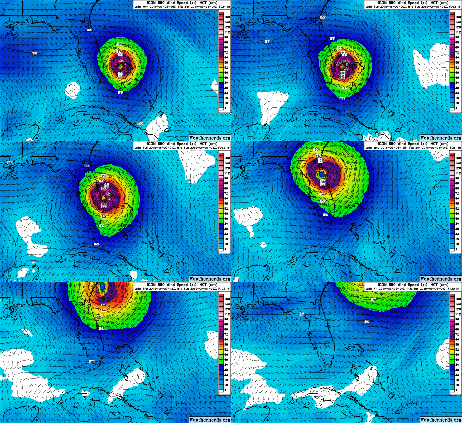
In addition, there is still a small possibility Dorian heads straight west to Palm Beach or Northwest to the Cape Canaveral area.
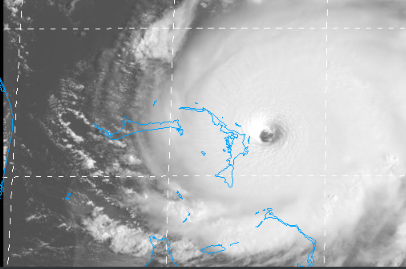

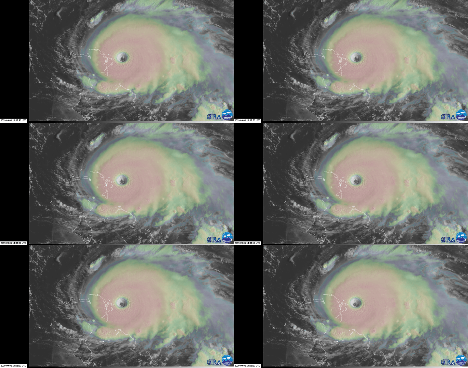
burst of lightning as it intensifies -
ICON model forecast -
https://uploads.disquscdn.com/images...3b4f588110.gif
HWRF model forecast (hit play button) -
https://www.tropicaltidbits.com/anal...19090106&fh=81
Dorian is a 180 mph monster
There will be catastrophic damage in the Northern Bahamas at Abaco and Grand Bahama. These are populated areas. I feel sorry for the people still there. They are about to go through a nightmare.
Hurricane Dorian Discussion Number 33
NWS National Hurricane Center Miami FL AL052019
1100 AM EDT Sun Sep 01 2019
Air Force and NOAA reconnaissance planes penetrated the distinct
eye of Dorian, and found that the hurricane has become extremely
intense with a stadium effect in the eye. The NOAA plane reported a
peak flight-level wind of 159 kt, while the SFMR from both planes
have measured winds between 155 and 170 kt. A dropsonde from the
NOAA plane measured a wind gust of 176 kt at the surface. A blend of
these measurements yield to an initial intensity of 155 kt, making
Dorian the strongest hurricane on record in the northwestern
Bahamas.
For the next few days, Dorian should experience some fluctuations in
intensity, and in addition to eyewall replacement cyclone, the
interaction with the northwestern Bahamas should weaken the
hurricane slightly. After 3 days, as Dorian moves northward along
or offshore of southeast United States coast, the shear is forecast
to increase, resulting in a more distinct gradual weakening.
Reconnaissance plane and satellite fixes indicate that Dorian, as
anticipated, has slowed down and is moving toward the west or 270
degrees at 6 kt. The steering currents are collapsing and Dorian is
expected to slow down even more, prolonging its catastrophic effects
in the northwestern Bahamas. The NHC forecast calls for a slow west
to west-northwest motion during the next 48 hours, with a turn to
the north and an increase in forward speed as the mid-level trough
along the eastern United States deepens and becomes the dominant
steering feature. The current forecast is only a few miles west of
the previous one and is basically on top of the multi-model
consensus. Both the deterministic and consensus tracks have shown
the usual variability to the right or to the left from run to run,
but the overall trend is for the hurricane to turn northward
offshore but very close to the Florida peninsula.
Given the uncertainty in the track forecast and the anticipated
increase in size of the hurricane, a Hurricane Watch and Storm
Surge Watch have been issued for a portion of the east Florida
coast. It is emphasized that although the official track forecast
does not show landfall, users should not focus on the exact track. A
small deviation to the left of the track could bring the intense
core of the hurricane its dangerous winds closer to or onto the
coast.
Key Messages:
1. A prolonged period of catastrophic winds and storm surge will
affect the Abaco Islands today. Everyone there should take immediate
shelter and not venture into the eye. These catastrophic conditions
are likely on Grand Bahama Island later today or tonight, and
efforts to protect life and property there should be rushed to
completion.
2. Storm surge and hurricane watches and tropical storm warnings are
in effect for portions of the Florida east coast. Life-threatening
storm surge and dangerous hurricane-force winds are possible along
portions of the Florida east coast through mid-week, as only a
slight deviation to the left of the official forecast would bring
the core of Dorian near or over the coast. Residents should listen
to advice given by local emergency officials.
3. There is an increasing likelihood of strong winds and dangerous
storm surge along the coasts of Georgia, South Carolina, and North
Carolina later this week. Residents in these areas should continue
to monitor the progress of Dorian.
4. Heavy rains, capable of producing life-threatening flash floods,
are possible over northern portions of the Bahamas and coastal
sections of the southeast and lower mid-Atlantic regions of the
United States through late this week.
FORECAST POSITIONS AND MAX WINDS
INIT 01/1500Z 26.5N 76.8W 155 KT 180 MPH
12H 02/0000Z 26.6N 77.7W 150 KT 175 MPH
24H 02/1200Z 26.8N 78.5W 145 KT 165 MPH
36H 03/0000Z 27.0N 79.0W 135 KT 155 MPH
48H 03/1200Z 27.4N 79.4W 120 KT 140 MPH
72H 04/1200Z 29.7N 80.2W 100 KT 115 MPH
96H 05/1200Z 32.5N 79.0W 85 KT 100 MPH
120H 06/1200Z 35.5N 74.5W 80 KT 90 MPH
from -https://www.nhc.noaa.gov/text/refres.../011457.shtml?
In addition, there is still a small possibility Dorian heads straight west to Palm Beach or Northwest to the Cape Canaveral area.
burst of lightning as it intensifies -
ICON model forecast -
https://uploads.disquscdn.com/images...3b4f588110.gif
HWRF model forecast (hit play button) -
https://www.tropicaltidbits.com/anal...19090106&fh=81
09-01-2019, 09:19 AM
-
#320
- Joesky20
- Registered User
-

- Joesky20
- Registered User
- Join Date: Oct 2013
- Location: Florida, United States
- Age: 32
- Posts: 1,498
- Rep Power: 11041
-
-
321 cocoa beach brah here. Riding out the storm like every year.. always blown way out of proportion.. like every year.
Deadlift: 435
Squat: 365
Bench: 325
OHP: 200
09-01-2019, 09:20 AM
-
#321
- iifymbro
- Registered User
-

- iifymbro
- Registered User
- Join Date: Jan 2015
- Location: United States
- Age: 37
- Posts: 21,395
- Rep Power: 112562
-
-
Originally Posted By HairyWBush⏩
https://www.cyclocane.com/dorian-spaghetti-models/someone help me out here. my little tracker says the current movement is STILL West. How are we seeing it's going to go north and probably not make landfall?
https://www.nhc.noaa.gov/refresh/gra...923.shtml?cone
theres a pressure ridge north that needs to die before the turn north can happen, we just waiting on that
**MFC**
**Barbara Palvin is my 10/10 crew**
09-01-2019, 09:22 AM
-
#322
 09-01-2019, 09:39 AM
-
#323
09-01-2019, 09:41 AM
-
#324

Originally Posted By Sezzors⏩
Can't really compare it to a tornado. Tornadoes will always be the most powerful and strongest storm in the world. This hurricane will easily do widespread ef3 and maybe ef4 damage though.Damn 180mph winds now, at this point it’s just a giant tornado isn’t it?
Stay safe broskis
Stay safe broskis
PC specs
i9 9900k/AMD RX 6800 16 GB/16 GB RAM/LG BX 65'' OLED/Gigabyte GS27QC 27''
OLED Master Race crew
1440p 120+ fps only crew
6'2 master race crew
Audiophile crew
Metal crew
Introvert/INTJ crew
German crew
If you aren't getting stronger you aren't getting bigger crew
09-01-2019, 10:08 AM
-
#325
- propreffered7
- Registered User
-

- propreffered7
- Registered User
- Join Date: Mar 2010
- Posts: 36,839
- Rep Power: 86393
-
-
Originally Posted By eod8989⏩
depends on how you define "powerful"Can't really compare it to a tornado. Tornadoes will always be the most powerful and strongest storm in the world. This hurricane will easily do widespread ef3 and maybe ef4 damage though.
if you're talking about wind speeds and the core itself.. probably
but hurricanes bring with it tonsss more. storm surge, down pour, etc.
"Contributed by Roger Edwards, Storm Prediction Center:
The differences are in scale. Even though winds from the strongest tornadoes far exceed that from the strongest hurricanes, hurricanes typically cause much more damage individually and over a season, and over far bigger areas. Economically, tornadoes cause about a tenth as much damage per year, on average, as hurricanes. Hurricanes tend to cause much more overall destruction than tornadoes because of their much larger size, longer duration and their greater variety of ways to damage property. The destructive core in hurricanes can be tens of miles across, last many hours and damage structures through storm surge and rainfall-caused flooding, as well as from wind. Tornadoes, in contrast, tend to be a few hundred yards in diameter, last for minutes and primarily cause damage from their extreme winds.""
The differences are in scale. Even though winds from the strongest tornadoes far exceed that from the strongest hurricanes, hurricanes typically cause much more damage individually and over a season, and over far bigger areas. Economically, tornadoes cause about a tenth as much damage per year, on average, as hurricanes. Hurricanes tend to cause much more overall destruction than tornadoes because of their much larger size, longer duration and their greater variety of ways to damage property. The destructive core in hurricanes can be tens of miles across, last many hours and damage structures through storm surge and rainfall-caused flooding, as well as from wind. Tornadoes, in contrast, tend to be a few hundred yards in diameter, last for minutes and primarily cause damage from their extreme winds.""
"Hurricanes in the continental U.S. cause on average about $3 billion per landfall and about $5 billion annually (Pielke and Landsea 1998). The roughly 1000 tornadoes that impact the continental U.S.each year cause about ten times less - about $500 million in total ( Brooks and Doswell 2001)"
09-01-2019, 10:32 AM
-
#326
- the700level
- Registered User
-

- the700level
- Registered User
- Join Date: Jun 2009
- Posts: 8,870
- Rep Power: 25761
-
-
RIP Bahamas
- Disregard females, acquire real estate
- MAGA
- Fauci for prison
- Pureblood
09-01-2019, 10:43 AM
-
#327
- LukeLissen
- 📶 🔌🔋 99%
-
- LukeLissen
- 📶 🔌🔋 99%
- Join Date: Mar 2013
- Location: United States
- Posts: 27,092
- Rep Power: 192151
-
-
09-01-2019, 10:47 AM
-
#328
- LukeLissen
- 📶 🔌🔋 99%
-
- LukeLissen
- 📶 🔌🔋 99%
- Join Date: Mar 2013
- Location: United States
- Posts: 27,092
- Rep Power: 192151
-
-

For comparison, cat 5 Hurricane Andrew was 922 at landfall.
09-01-2019, 10:47 AM
-
#329

- achtungpanzer
- Join Date: Apr 2014
- Location: Florida, United States
- Height: 6'1"
- Weight: 215 lbs
- Posts: 9,522
- Subscribers: 5
- Rep Power: 251061
-
-

09-01-2019, 10:51 AM
-
#330
- LukeLissen
- 📶 🔌🔋 99%
-
- LukeLissen
- 📶 🔌🔋 99%
- Join Date: Mar 2013
- Location: United States
- Posts: 27,092
- Rep Power: 192151
-
-

Bookmarks
-

- Digg
-

- del.icio.us
-

- StumbleUpon
-

-

Posting Permissions
- You may not post new threads
- You may not post replies
- You may not post attachments
- You may not edit your posts