
 08-26-2021, 02:14 PM
-
#1
- armyr0b
- Registered User
-

- armyr0b
- Registered User
- Join Date: Jan 2008
- Location: Connecticut, United States
- Age: 46
- Posts: 6,321
- Rep Power: 21214
-
-

Tropical Storm Ida - Louisiana - SRS
Looks like Hurricane season is going all ahead. Tropical depression has just formed and its making a pretty straight shot over the GOM with super warm SST and minimal shear. It is an ideal location to intensify a tropical storm. If you live in the Louisiana area please start to take notice, early modeling is showing a monster storm.
941mb translates to about a Cat4/5 hurricane

spaghetti modeling

euro run


Latest from NHC

941mb translates to about a Cat4/5 hurricane
spaghetti modeling
euro run
Latest from NHC
PS4
New England Patriots
08-26-2021, 02:20 PM
-
#2
- hendrixfreak70
- My eyes are up here.
-

- hendrixfreak70
- My eyes are up here.
- Join Date: Feb 2016
- Location: United States
- Posts: 29,433
- Subscribers: 17
- Rep Power: 752331
-
-

Was expecting an EOD thread honestly.
08-26-2021, 02:22 PM
-
#3
- ParsleyTea
- Registered User
-

- ParsleyTea
- Registered User
- Join Date: Nov 2009
- Age: 56
- Posts: 13,588
- Rep Power: 50203
-
-
Louisiana has been very unlucky with hurricanes of late.
08-26-2021, 03:27 PM
-
#4
- armyr0b
- Registered User
-
- armyr0b
- Registered User
- Join Date: Jan 2008
- Location: Connecticut, United States
- Age: 46
- Posts: 6,321
- Rep Power: 21214
-
-
Originally Posted By ParsleyTea⏩
to add to that "I" named storms have been quite prolific as well. this all does not bode well for that general area. it could shift east towards the panhandle as well.Louisiana has been very unlucky with hurricanes of late.
PS4
New England Patriots
08-26-2021, 03:37 PM
-
#5
- Redfish225
- Hunter/Fisherbreh
-

- Redfish225
- Hunter/Fisherbreh
- Join Date: Aug 2012
- Posts: 69,167
- Rep Power: 903956
-
-
Louisiana crew. Fukk ida, I have a whole home generator and a bar in my house.
I loe e.
08-27-2021, 07:46 AM
-
#6
- armyr0b
- Registered User
-
- armyr0b
- Registered User
- Join Date: Jan 2008
- Location: Connecticut, United States
- Age: 46
- Posts: 6,321
- Rep Power: 21214
-
-
here are some of the latest modeling. NHC has this coming in as a Major hurricane. pepper your angus. ****s getting real
ICON 6z

GFS 6z

HWRF 6z


ICON 6z
GFS 6z
HWRF 6z
PS4
New England Patriots
08-27-2021, 10:12 AM
-
#7
- Redfish225
- Hunter/Fisherbreh
-
- Redfish225
- Hunter/Fisherbreh
- Join Date: Aug 2012
- Posts: 69,167
- Rep Power: 903956
-
-
Originally Posted By armyr0b⏩
here are some of the latest modeling. NHC has this coming in as a Major hurricane. pepper your angus. ****s getting real
ICON 6z
GFS 6z
HWRF 6z
ICON 6z
GFS 6z
HWRF 6z

I loe e.
08-27-2021, 10:24 AM
-
#8
- armyr0b
- Registered User
-
- armyr0b
- Registered User
- Join Date: Jan 2008
- Location: Connecticut, United States
- Age: 46
- Posts: 6,321
- Rep Power: 21214
-
-
ocean heat content, this will be going over some very very warm watere

eyewall looks like it is trying to close up completely
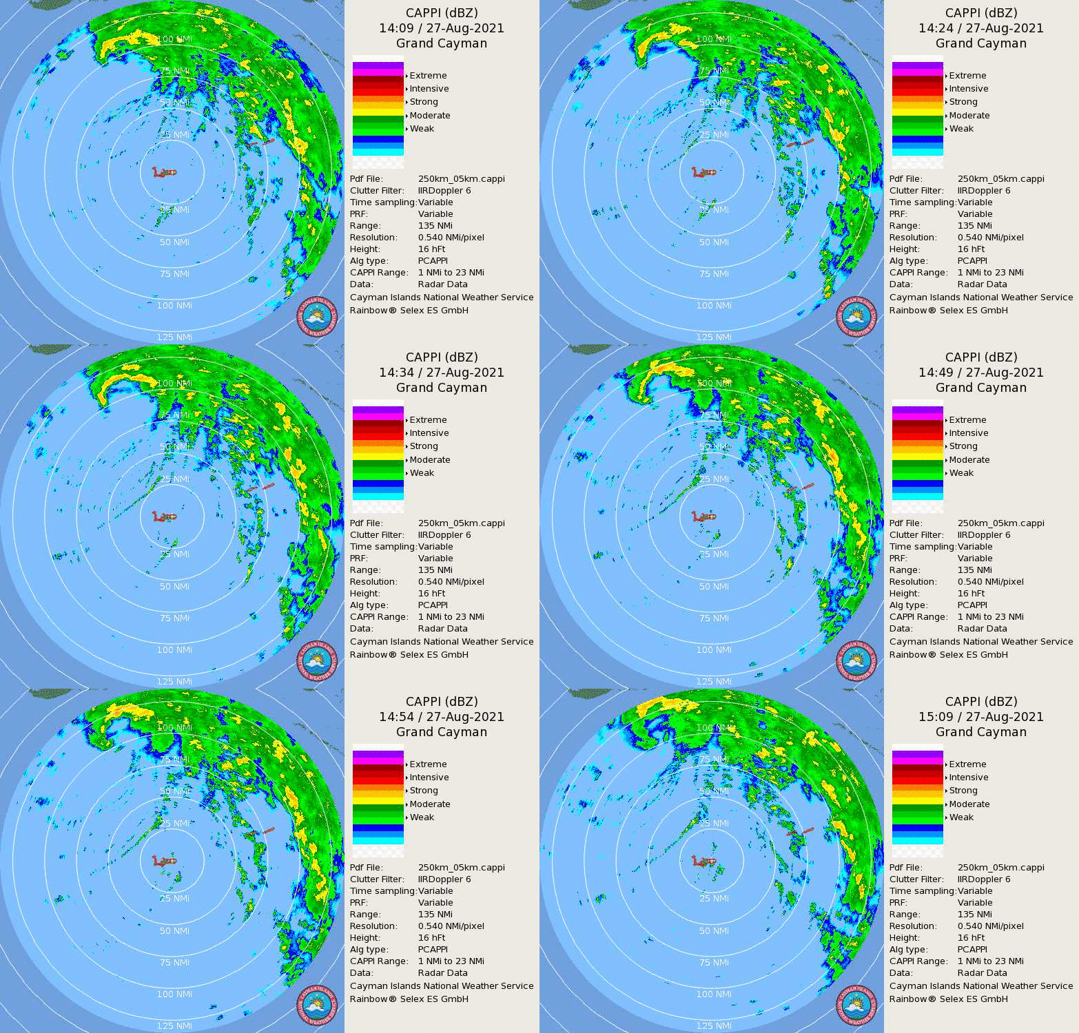
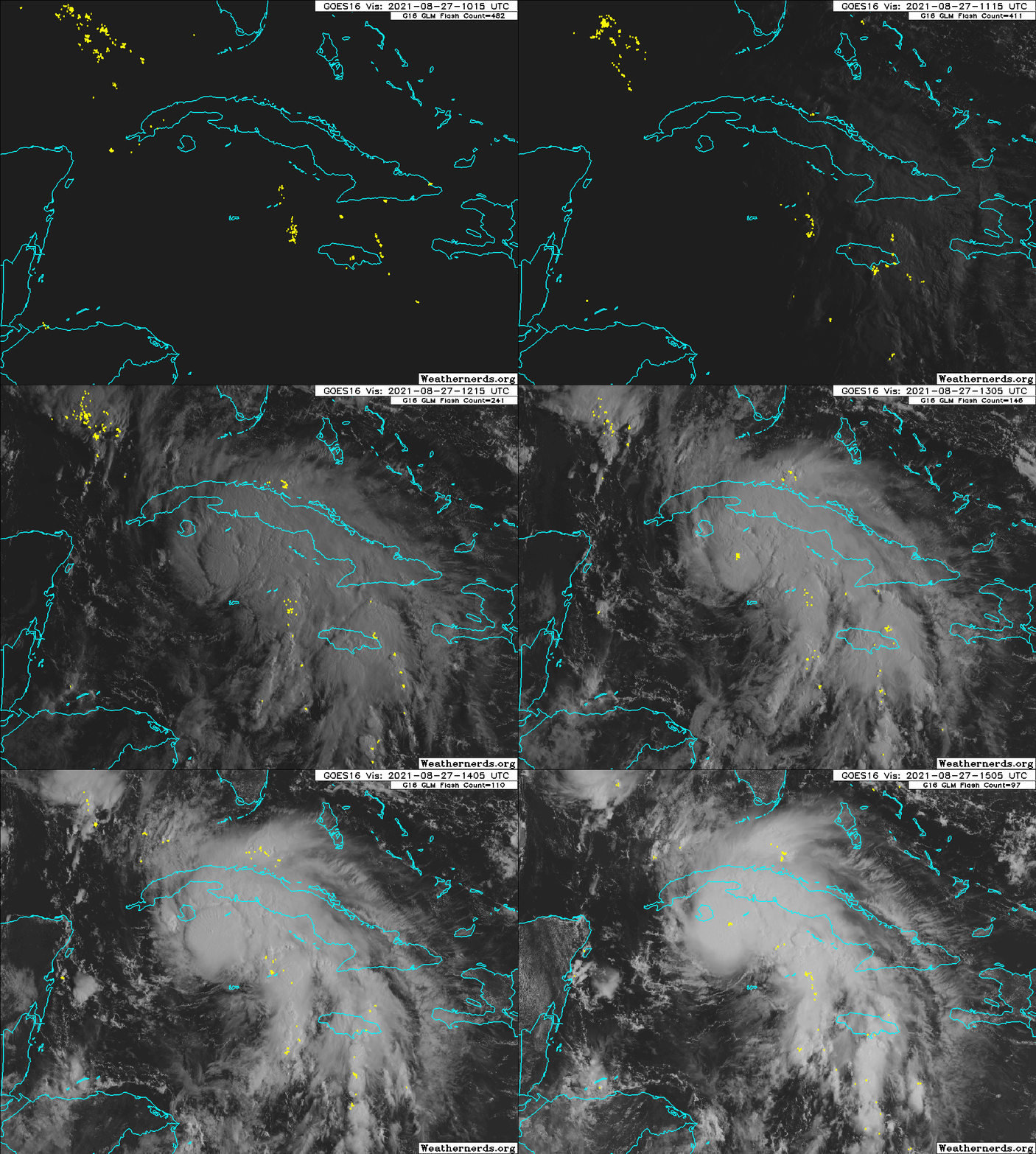
06z euro ensembles

12z ICON


12z GFS

PS4
New England Patriots
08-27-2021, 10:29 AM
-
#9
- darkninja67
- The Dark Lord
-

- darkninja67
- The Dark Lord
- Join Date: Aug 2009
- Posts: 87,403
- Rep Power: 802217
-
-
are you the Misc weather guy that gave out info during one really bad winter here in NE??
rumpler of stiltskins
"I'm not afraid to die, I'm afraid I'll survive and have to watch you suffer" - Thy Art Is Murder
"Life will cease so breathe deep" - Lorna Shore
08-27-2021, 10:31 AM
-
#10
- armyr0b
- Registered User
-
- armyr0b
- Registered User
- Join Date: Jan 2008
- Location: Connecticut, United States
- Age: 46
- Posts: 6,321
- Rep Power: 21214
-
-
Originally Posted By darkninja67⏩
maybe. i know there was someone else that has posted.are you the Misc weather guy that gave out info during one really bad winter here in NE??
i just find this stuff really interesting and figure it could help someone out. i am tracking this stuff regardless. only takes a few moments to update the thread.
hope we get some solid storms this year. need more snow
PS4
New England Patriots
08-27-2021, 10:32 AM
-
#11
- darkninja67
- The Dark Lord
-
- darkninja67
- The Dark Lord
- Join Date: Aug 2009
- Posts: 87,403
- Rep Power: 802217
-
-
Originally Posted By armyr0b⏩
There was some dude (maybe you) that always posted info on blizzards coming up and stuff like that.maybe. i know there was someone else that has posted.
i just find this stuff really interesting and figure it could help someone out. i am tracking this stuff regardless. only takes a few moments to update the thread.
hope we get some solid storms this year. need more snow
i just find this stuff really interesting and figure it could help someone out. i am tracking this stuff regardless. only takes a few moments to update the thread.
hope we get some solid storms this year. need more snow
rumpler of stiltskins
"I'm not afraid to die, I'm afraid I'll survive and have to watch you suffer" - Thy Art Is Murder
"Life will cease so breathe deep" - Lorna Shore
08-27-2021, 10:41 AM
-
#12

- xxAchillesxx
- Join Date: Sep 2008
- Posts: 19,524
- Subscribers: 2
- Rep Power: 389901
-
-
After it gets past Cuba it's full steam ahead. The Caribbean and Gulf temps are like rocket fuel right now.
"The dildo of consequences rarely arrives lubed."
See OptimusTrajan' sig
08-27-2021, 10:55 AM
-
#13
 08-27-2021, 11:04 AM
-
#14
- CuttyUnderleaf
- Unregistered User
-

- CuttyUnderleaf
- Unregistered User
- Join Date: Feb 2020
- Posts: 6,205
- Rep Power: 182033
-
-
No...

08-27-2021, 11:17 AM
-
#15
- armyr0b
- Registered User
-
- armyr0b
- Registered User
- Join Date: Jan 2008
- Location: Connecticut, United States
- Age: 46
- Posts: 6,321
- Rep Power: 21214
-
-
Originally Posted By darkninja67⏩
probably was me, cause i do remember posting about them. will continue to do so. since you are in boston, im sure they will be helpful.There was some dude (maybe you) that always posted info on blizzards coming up and stuff like that.
PS4
New England Patriots
08-27-2021, 11:19 AM
-
#16
- armyr0b
- Registered User
-
- armyr0b
- Registered User
- Join Date: Jan 2008
- Location: Connecticut, United States
- Age: 46
- Posts: 6,321
- Rep Power: 21214
-
-
Originally Posted By xxAchillesxx⏩
the unfortunate part of cuba is that the terrain is relatively flat, no more than some hills at 1500 ft and only a 40 mile run across. it really shouldnt affect the organization of this system. this system has all the necessary parts to be a monster. lets hope something happens and its not a worst case scenario and it landfalls in the swamps and bayous.After it gets past Cuba it's full steam ahead. The Caribbean and Gulf temps are like rocket fuel right now.
PS4
New England Patriots
08-27-2021, 11:20 AM
-
#17
- armyr0b
- Registered User
-
- armyr0b
- Registered User
- Join Date: Jan 2008
- Location: Connecticut, United States
- Age: 46
- Posts: 6,321
- Rep Power: 21214
-
-
Originally Posted By Tears⏩
you must bench like 350 yeahIt’s strange how people like OP throw these gay little hurricane parties every single time the news informs that rain is coming. Chit got old 10 years ago
PS4
New England Patriots
08-27-2021, 11:21 AM
-
#18
- sword_
- uberschwert
-

- sword_
- uberschwert
- Join Date: May 2005
- Location: Texas, United States
- Posts: 107,635
- Rep Power: 912964
-
-
Damn good luck Gulf Coast.
A hit was sent, from the President, to raid your residence /
Because you had secret evidence, and documents /
On how they raped the continents, and it's the prominent /
Dominant Islamic, Asiatic Black Hebrew
- GZA "4th Chamber"
08-27-2021, 11:22 AM
-
#19
- Redfish225
- Hunter/Fisherbreh
-
- Redfish225
- Hunter/Fisherbreh
- Join Date: Aug 2012
- Posts: 69,167
- Rep Power: 903956
-
-
08-27-2021, 11:24 AM
-
#20
 08-27-2021, 11:40 AM
-
#21
- armyr0b
- Registered User
-
- armyr0b
- Registered User
- Join Date: Jan 2008
- Location: Connecticut, United States
- Age: 46
- Posts: 6,321
- Rep Power: 21214
-
-
OFFICIALLY A HURRICANE NOW

its definitely finding its shape


looks like the eye has formed on radar

with only about 2.5 hours over cuba this thing is gonna go straight ballistic
its definitely finding its shape
looks like the eye has formed on radar
with only about 2.5 hours over cuba this thing is gonna go straight ballistic
PS4
New England Patriots
08-27-2021, 11:42 AM
-
#22
- HannoCometh
- Gingers are human too
-

- HannoCometh
- Gingers are human too
- Join Date: Apr 2019
- Posts: 18,566
- Rep Power: 9117
-
-
"Andrew, take us to DEFCON TWO."
Battlefield 8 fan
Betelgeuse is coming Crew
Gliese 710 Crew
"Phytoandrogens are a thing, apparently..."
-Comments attributed to HannoCometh (2021)
•|PHYTOANDROGENS (discovered by Misc around March '21)|•
••||02/22/22 - Acquired The Moncler Space Company, former subsidiary of Moncler S.p.A ded fkn srs
••||02/24/22 - Honorary Director for life (USFS and USDOI Bureau of Land Management)
Aspiring Sasquatch Crew
Anti-soya Crew
Active service, War on Soya [2021-ongoing]
08-27-2021, 11:46 AM
-
#23


 08-27-2021, 12:19 PM
-
#24
- xxAchillesxx
- Join Date: Sep 2008
- Posts: 19,524
- Subscribers: 2
- Rep Power: 389901
-
-
Camille 2.0

"The dildo of consequences rarely arrives lubed."
See OptimusTrajan' sig
08-27-2021, 02:55 PM
-
#25
08-27-2021, 02:58 PM
-
#26
- armyr0b
- Registered User
-
- armyr0b
- Registered User
- Join Date: Jan 2008
- Location: Connecticut, United States
- Age: 46
- Posts: 6,321
- Rep Power: 21214
-
-
ZCZC MIATCDAT4 ALL
TTAA00 KNHC DDHHMM
Hurricane Ida Discussion Number 6
NWS National Hurricane Center Miami FL AL092021
500 PM EDT Fri Aug 27 2021
Cuban radar data and reports from an earlier Air Force Reserve
Hurricane Hunter mission indicate that Ida's inner core structure
continued to improve after the release of the previous advisory
package. An eye became apparent in radar imagery before the center
reached the Isle of Youth, and the final fix from the Air Force
Hurricane Hunter aircraft reported a closed 24-n-mi wide eye. The
aircraft measured winds to support hurricane intensity shortly
before 1800 UTC, and during the final northeast eyewall pass, and
flight-level wind data support increasing the intensity to 70 kt,
which is used as the initial intensity for this advisory.
The upper-level outflow has expanded over all but the southwestern
portion of the circulation, and the upper-level wind pattern is
forecast to continue to improve overnight and early Saturday.
Once Ida moves past western Cuba and into the southeastern Gulf of
Mexico, it will be moving through a very favorable oceanic and
atmospheric environment consisting of high ocean heat content
waters, low vertical wind shear, and a moist low- to mid-level
atmosphere. These conditions are likely to result in a period
of rapid strengthening during the next 24 to 36 hours. In fact,
with the higher initial wind speed, the intensity guidance has
significantly increased this cycle, and the bulk of the guidance
now brings Ida to category 4 intensity. The NHC forecast explicitly
calls for rapid intensification during the next 24 to 36 hours,
which is supported by several of the dynamical models, the LGEM
model, and high probabilities of rapid intensification indicated
by the SHIPS and DTOPS RI guidance. The NHC forecast is near
the IVCN multi-model consensus aid, but is lower than HCCA and
LGEM. It should be noted that some fluctuations in intensity are
possible as Ida nears the northern Gulf coast due to possible
eyewall replacement cycles. In addition to the expected increase in
strength, the dynamical model guidance again calls for Ida's wind
field to expand while it moves over the Gulf of Mexico. As a
result, there is higher-than-normal confidence that a large and
powerful hurricane will impact portions of the northern Gulf coast
by late this weekend and early next week.
Ida has wobbled a little right of the previous track, but the longer
term motion continues to be northwestward or 320/13 kt. The steering
currents remain well-established as a strong deep-layer ridge over
the western Atlantic should continue to steer Ida northwestward
across the Gulf this weekend. Ida will approach the western
portion of the ridge after landfall, and this should result in a
slower northward motion by day 3. After that time, a short-wave
trough over the central United States is expected to cause the
system to turn northeastward. The track guidance remains in
remarkably good agreement through landfall along the northern Gulf
coast, and there is higher-than-normal confidence in that portion of
the track forecast. However, users are again reminded to not focus
on the exact details of the track forecast as storm surge, wind,
and rainfall impacts will extend far from the center.
Key Messages:
1. Life-threatening storm surge and hurricane conditions are
expected to continue through tonight in portions of western Cuba,
including the Isle of Youth, where a Hurricane Warning is in effect.
Life-threatening heavy rains, flash flooding and mudslides are
expected across Jamaica, the Cayman Islands, and western Cuba,
including the Isle of Youth.
2. There is a danger of life-threatening storm surge inundation
Sunday along the coasts of Louisiana and Mississippi within the
Storm Surge Warning area. Extremely life-threatening inundation of
10 to 15 feet above ground level is possible within the area from
Morgan City, Louisiana, to the Mouth of the Mississippi River.
Interests throughout the warning area should follow any advice given
by local officials.
3. Ida is expected to be an extremely dangerous major hurricane when
it reaches the coast of Louisiana. Hurricane-force winds are
expected Sunday in portions of the Hurricane Warning area along the
Louisiana coast, including metropolitan New Orleans, with
potentially catastrophic wind damage possible where the core of Ida
moves onshore. Actions to protect life and property should be rushed
to completion in the warning area.
4. Ida is likely to produce heavy rainfall later Sunday into Monday
across the central Gulf Coast from southeast Louisiana to coastal
Mississippi and Alabama, resulting in considerable flash, urban,
small stream, and riverine flooding impacts. As Ida moves inland,
flooding impacts are possible across portions of the Lower
Mississippi and Tennessee Valleys.
FORECAST POSITIONS AND MAX WINDS
INIT 27/2100Z 22.1N 83.2W 70 KT 80 MPH
12H 28/0600Z 23.5N 84.8W 85 KT 100 MPH
24H 28/1800Z 25.3N 86.9W 105 KT 120 MPH
36H 29/0600Z 27.1N 89.0W 115 KT 130 MPH
48H 29/1800Z 28.6N 90.6W 120 KT 140 MPH
60H 30/0600Z 30.0N 91.3W 80 KT 90 MPH...INLAND
72H 30/1800Z 31.5N 91.1W 40 KT 45 MPH...INLAND
96H 31/1800Z 34.4N 89.3W 30 KT 35 MPH...INLAND
120H 01/1800Z 36.0N 86.0W 20 KT 25 MPH...POST-TROP/REMNT LOW
TTAA00 KNHC DDHHMM
Hurricane Ida Discussion Number 6
NWS National Hurricane Center Miami FL AL092021
500 PM EDT Fri Aug 27 2021
Cuban radar data and reports from an earlier Air Force Reserve
Hurricane Hunter mission indicate that Ida's inner core structure
continued to improve after the release of the previous advisory
package. An eye became apparent in radar imagery before the center
reached the Isle of Youth, and the final fix from the Air Force
Hurricane Hunter aircraft reported a closed 24-n-mi wide eye. The
aircraft measured winds to support hurricane intensity shortly
before 1800 UTC, and during the final northeast eyewall pass, and
flight-level wind data support increasing the intensity to 70 kt,
which is used as the initial intensity for this advisory.
The upper-level outflow has expanded over all but the southwestern
portion of the circulation, and the upper-level wind pattern is
forecast to continue to improve overnight and early Saturday.
Once Ida moves past western Cuba and into the southeastern Gulf of
Mexico, it will be moving through a very favorable oceanic and
atmospheric environment consisting of high ocean heat content
waters, low vertical wind shear, and a moist low- to mid-level
atmosphere. These conditions are likely to result in a period
of rapid strengthening during the next 24 to 36 hours. In fact,
with the higher initial wind speed, the intensity guidance has
significantly increased this cycle, and the bulk of the guidance
now brings Ida to category 4 intensity. The NHC forecast explicitly
calls for rapid intensification during the next 24 to 36 hours,
which is supported by several of the dynamical models, the LGEM
model, and high probabilities of rapid intensification indicated
by the SHIPS and DTOPS RI guidance. The NHC forecast is near
the IVCN multi-model consensus aid, but is lower than HCCA and
LGEM. It should be noted that some fluctuations in intensity are
possible as Ida nears the northern Gulf coast due to possible
eyewall replacement cycles. In addition to the expected increase in
strength, the dynamical model guidance again calls for Ida's wind
field to expand while it moves over the Gulf of Mexico. As a
result, there is higher-than-normal confidence that a large and
powerful hurricane will impact portions of the northern Gulf coast
by late this weekend and early next week.
Ida has wobbled a little right of the previous track, but the longer
term motion continues to be northwestward or 320/13 kt. The steering
currents remain well-established as a strong deep-layer ridge over
the western Atlantic should continue to steer Ida northwestward
across the Gulf this weekend. Ida will approach the western
portion of the ridge after landfall, and this should result in a
slower northward motion by day 3. After that time, a short-wave
trough over the central United States is expected to cause the
system to turn northeastward. The track guidance remains in
remarkably good agreement through landfall along the northern Gulf
coast, and there is higher-than-normal confidence in that portion of
the track forecast. However, users are again reminded to not focus
on the exact details of the track forecast as storm surge, wind,
and rainfall impacts will extend far from the center.
Key Messages:
1. Life-threatening storm surge and hurricane conditions are
expected to continue through tonight in portions of western Cuba,
including the Isle of Youth, where a Hurricane Warning is in effect.
Life-threatening heavy rains, flash flooding and mudslides are
expected across Jamaica, the Cayman Islands, and western Cuba,
including the Isle of Youth.
2. There is a danger of life-threatening storm surge inundation
Sunday along the coasts of Louisiana and Mississippi within the
Storm Surge Warning area. Extremely life-threatening inundation of
10 to 15 feet above ground level is possible within the area from
Morgan City, Louisiana, to the Mouth of the Mississippi River.
Interests throughout the warning area should follow any advice given
by local officials.
3. Ida is expected to be an extremely dangerous major hurricane when
it reaches the coast of Louisiana. Hurricane-force winds are
expected Sunday in portions of the Hurricane Warning area along the
Louisiana coast, including metropolitan New Orleans, with
potentially catastrophic wind damage possible where the core of Ida
moves onshore. Actions to protect life and property should be rushed
to completion in the warning area.
4. Ida is likely to produce heavy rainfall later Sunday into Monday
across the central Gulf Coast from southeast Louisiana to coastal
Mississippi and Alabama, resulting in considerable flash, urban,
small stream, and riverine flooding impacts. As Ida moves inland,
flooding impacts are possible across portions of the Lower
Mississippi and Tennessee Valleys.
FORECAST POSITIONS AND MAX WINDS
INIT 27/2100Z 22.1N 83.2W 70 KT 80 MPH
12H 28/0600Z 23.5N 84.8W 85 KT 100 MPH
24H 28/1800Z 25.3N 86.9W 105 KT 120 MPH
36H 29/0600Z 27.1N 89.0W 115 KT 130 MPH
48H 29/1800Z 28.6N 90.6W 120 KT 140 MPH
60H 30/0600Z 30.0N 91.3W 80 KT 90 MPH...INLAND
72H 30/1800Z 31.5N 91.1W 40 KT 45 MPH...INLAND
96H 31/1800Z 34.4N 89.3W 30 KT 35 MPH...INLAND
120H 01/1800Z 36.0N 86.0W 20 KT 25 MPH...POST-TROP/REMNT LOW
PS4
New England Patriots
08-27-2021, 03:08 PM
-
#27

 08-27-2021, 03:13 PM
-
#28
- keyboardworkout
- ChatGPT4.5 Bot
-

- keyboardworkout
- ChatGPT4.5 Bot
- Join Date: Jul 2009
- Posts: 36,953
- Rep Power: 416934
-
-
Projected Cat 4 baby

▪█─────█▪ Equipment Crew #53 ▪█─────█▪
^^^^^^^ 6' 6" and Over Crew ^^^^^^^
------------- No Vax Crew ----------------
08-27-2021, 03:39 PM
-
#29
- MyLastSerenade
- Registered User
-

- MyLastSerenade
- Registered User
- Join Date: Dec 2007
- Location: Dallas, Texas, United States
- Age: 42
- Posts: 10,028
- Rep Power: 68065
-
-
I maybe mistaken, but it is looking as all computer models are pointing it at NOLA. Only slight deviations.


I would rather die than live my life in fear.- KSE
Don't Panic and always carry a towel.

Bookmarks
-

- Digg
-

- del.icio.us
-

- StumbleUpon
-

-

Posting Permissions
- You may not post new threads
- You may not post replies
- You may not post attachments
- You may not edit your posts